
Myers Flat
Myers Flat is a rural/residential district on the Loddon Valley Highway 8 km north-west of Bendigo. It was named after the co-proprietor of the Weddikar pastoral run (1845), Thomas Myers. The name was probably given when gold was discovered there in 1852.
The resultant rush was not a large one, and the land also attracted farm settlers. An Anglican school was opened in 1854 and a Catholic school in 1860. There was a strong Irish influence, manifested in an active hurling team and in St Augustine’s Catholic church (1864) in Sailors Gully Road. There was an inrush of miners in 1867, but the farm selection blocks (1869) produced a more enduring population growth. Farm families were predominantly Irish, growing stock feed, fruit and vegetables.
The Catholic school continued until 1908 when superseded by St Liborius school in Eaglehawk. A government school was opened in 1875, and renamed Maiden Gully in 1938 (494 pupils, 2014).
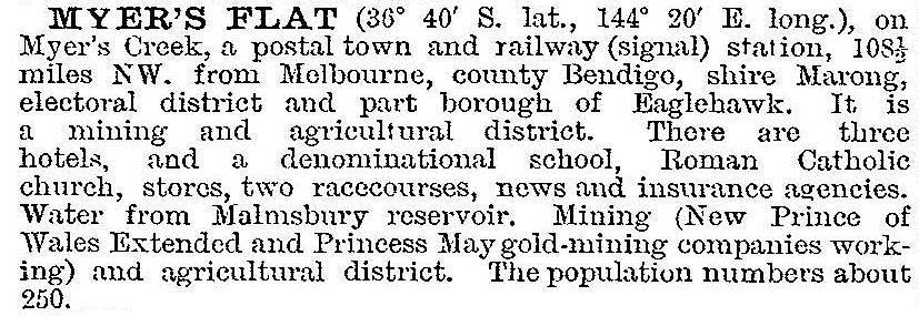
In 1903 Myers Flat was described in the Australian handbook:
Myers Flat has whipstick forest reserves to its east and west. A tourist attraction, Sandhurst Town, was developed about 2 km south-west in the 1970s but has ceased. Myers Flat’s chief attraction is as a residential location within easy proximity of Bendigo. The Catholic church is a prominent landmark.
Myers Flat’s census populations have been:
| census date | population |
|---|---|
| 1871 | 86 |
| 1891 | 275 |
| 1911 | 533 |
| 1921 | 93 |
| 2006 | 251 |
| 2011 | 400 |
Further Reading
From then ‘til now: St Augustine’s Myers Flat, 1864-1989, St Augustine’s 125th anniversary committee, 1990
Ken Arnold, Bendigo its environs: the way it was, Bendigo, 2003