
Shepparton Shire
Shepparton Shire (1879-1994), an area of 924 sq km, was east of Shepparton City and the Goulburn River in northern Victoria.
In its first form, the shire was a vast area severed from the even more vast Echuca Shire in 1879. As closer settlement and local irrigation schemes came into being, the first Shepparton shire was subdivided as follows. The creation of these shires went side by side with the creation of water and irrigation trusts:
| year | Shepparton Shire | Water and Irrigation Trusts |
|---|---|---|
| 1882 | Shire of Shepparton Waterworks Trust | |
| 1884 | Separate shires of ‘Shepparton’ and ‘South Shepparton’ | |
| 1885 |
‘Shepparton’ named Numurkah Shire ‘South Shepparton’ named Shepparton (Numurkah Shire included Numurkah and Nathalia) |
|
| 1886 |
Rodney Shire severed from Shepparton shire |
|
| 1889 | Rodney Irrigation Trust | |
| 1892 | Numurkah Waterworks Trust |
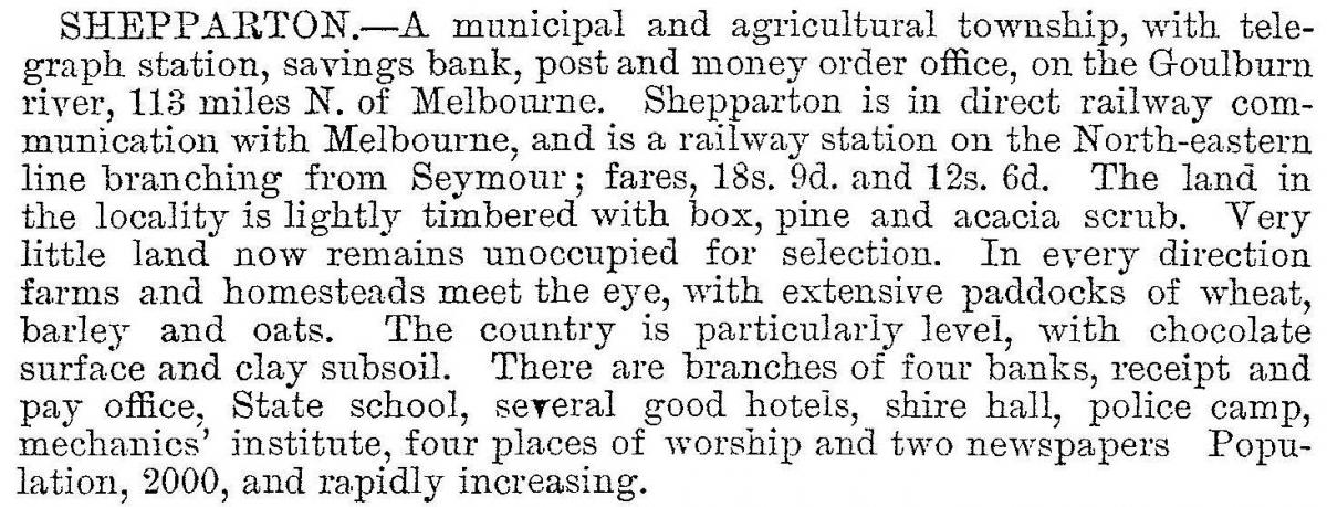
In 1885 the township and adjoining areas were described in the Victorian municipal directory:
The railway line was extended from Seymour to Shepparton in 1880, and further extended to Numurkah (1881) and east to Dookie (1888). The town of Shepparton was part of the shire until 1927.
As the railway extensions went ahead new towns were formed in irrigated farmlands: Congupra (1877); Pine Lodge (1878); Tallygaroopna (1877). Closer settlement and soldier settlement villages were dotted along the line to Dookie: Grahamvale (1910), Orrvale (1912), Shepparton East (1912) and Lemnos (1927).
At about the time of the outbreak of World War I many soft fruit orchards were producing big crops and the orderly marketing of fruit became a problem. The Shepparton Irrigators Association formed a cooperative cannery, the Shepparton Preserving Company (SPC) in 1917.
In 1936 a Shepparton East irrigator, John McDonald, was elected to the Victorian Parliament. He promoted the interests of growers and became Premier in 1950. He was instrumental in having the Goulburn Valley irrigation scheme enlarged by the construction of the Big Eildon dam in the early 1950s.
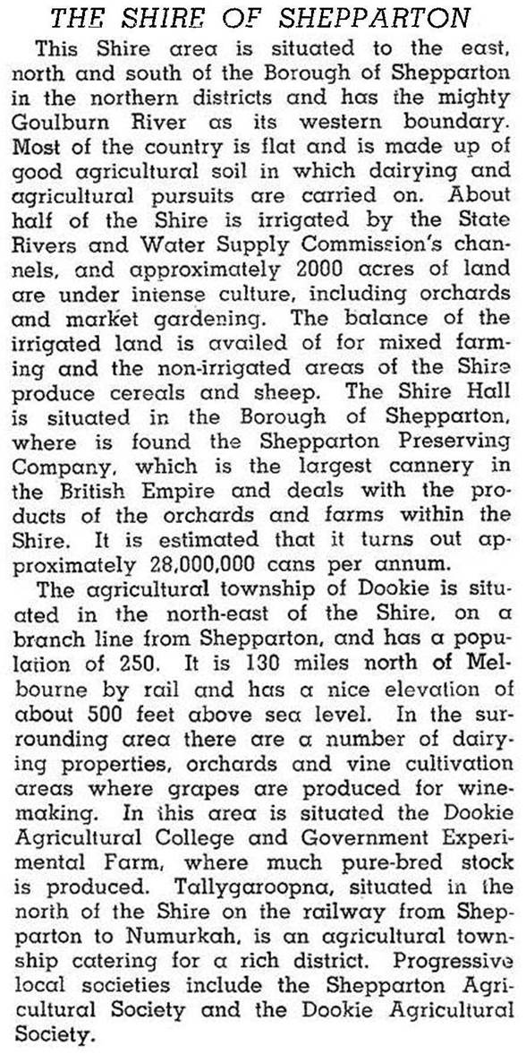
In 1946 the Australian blue book described the shire:
From the 1970s urban Shepparton began to spill into Shepparton shire. Despite parts of the shire being added to the city, the shire’s population went from about 6500 to 9000 by 1990.
The shire’s agricultural outputs were varied. In 1994 livestock comprised 23,000 dairy cattle, 20,000 meat cattle, 70,000 sheep, 29,000 lambs and 13,000 pigs. Orchards totalled 3355 hectares, and crops and sown pasture totalled 55,000 hectares. All farming occupied 78% of the shire’s area.
On 18 November 1994 Shepparton Shire was united with Shepparton city, most of Rodney Shire and parts of Euroa, Goulburn, Tungamah, Violet Town and Waranga Shires to form Greater Shepparton City (2420 sq km).
Shepparton Shire’s census populations were:
| census date | population |
|---|---|
| 1881 | 6594 |
| 1891 | 3781 |
| 1911 | 6099 |
| 1921 | 7711 |
| 1933 | 5529* |
| 1947 | 5278 |
| 1961 | 6133 |
| 1976 | 6470 |
| 1981 | 7470 |
| 1986 | 8270 |
| 1991 | 9070 |
*Shepparton town excised
Further Reading
Sue Wallace, Shepparton Shire reflections 1879-1979, Shire of Shepparton, 1979
Colin Martin, Irrigation and closer settlement in the Shepparton district, Carlton, 1955
Congupna, Dookie, Grahamvale, Kialla, Lemnos, Orrvale, Pine Lodge, Shepparton East and Tallygaroopna entries