
Rowsley
Rowsley is a rural locality 6 km south-west of Bacchus Marsh, where the Parwan Creek is crossed by the Bacchus Marsh-Balliang Road. Its name is thought to have been inspired by Rowsley in Derbyshire, England.
It has had a school (1870-1948), a mechanics' institute (1894) and a creamery. In 1889 the railway was laid through Rowsley connecting it to Ballarat and Melbourne. A siding replaced the station south of the Bacchus Marsh hardboard factory. In 1959 the mechanics' institute was replaced by a war memorial hall.
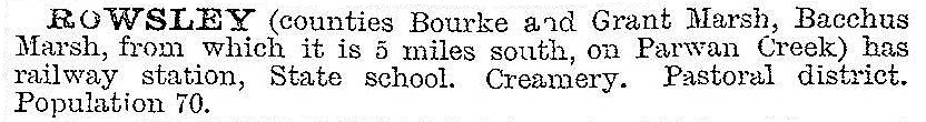
Rowsley was described in the 1903 Australian handbook:
The primary school was in Bacchus Marsh-Balliang Road, between Parwan Creek and the railway line. From there one can see the engineering works required to find adequate gradients for the railway to get around Bacchus Marsh. Travelling west from there, along Glenmore Road, there is the Greystones homestead (1876, Gothic bluestone), the Rowsley memorial hall and the Lady Northcote recreation camp, formerly a children’s farm for British children (1937-75).
The Rowsley geological fault is one of Victoria’s best known examples. The fault scarp gave rise to the Lerderderg and Brisbane Ranges. The uplifted hills rejuvenated streams which formed gorges.
Rowsley’s census populations have been:
| Census Date | Population |
|---|---|
| 1911 | 248 |
| 1966 | 121 |
| 2011 | 284 |
Further Reading
Gwyn Moore and Jean Oomes, Bacchus Marsh: a pictorial chronicle, Bacchus Marsh, 1986
Dorothy Pedretti, Rowsley hall 1894-1994, Bacchus Marsh, 1994