
Mount Egerton
Mount Egerton is a rural village 80 km north-west of Melbourne, about 10 km south of the Western Freeway. The nearest town is Gordon, a few kilometres to the north.
The mount was named after Charles Egerton, the owner of a pastoral property in the area.
In 1853 gold was discovered at Mount Egerton, and a reef was found to extend to the summit of the mount. Rich alluvial gold was also found in the All Nations gully. A school was opened in 1856, a Catholic church in 1868, and by the next decade there were also Wesleyan, Anglican and Presbyterian churches. There was also a mechanics' institute and a hotel or hotels, the number varying with the goldfield population.
The country around Mount Egerton is undulating and suited to grazing, ensuring a population not solely reliant on mining. Further south-west the land is hilly, enclosing the catchment for the Lal Lal reservoir.
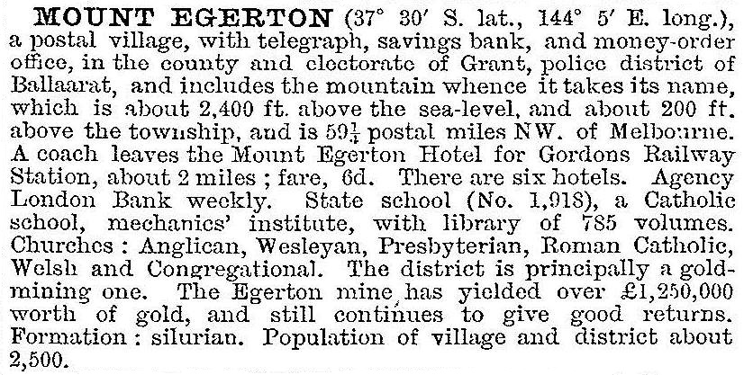
The Black Horse and Mount Egerton mining companies worked the reef from 1865 until 1910. Mount Egerton was described in the Australian handbook, 1903:
After the closure of the mines Mount Egerton relied on farming and a kaolin mine. In the 1980s it gained a tourist attraction with the Yuulong lavender farm. The township has a school (12 pupils, 2014), an oval, a general store, a Uniting church and a public hall. There is a formed road to the summit of the Mount.
Mining for gold was again carried out at Mount Egerton in 2005 when the town's progress association complained about the lack of adherence to the 100 metre buffer zone protecting the community from mining activity.
Mount Egerton's census populations have been:
| Census Date | Population |
|---|---|
| 1871 | 508 |
| 1881 | 1615 |
| 1891 | 913 |
| 1933 | 372 |
| 1966 | 152 |
| 2006 | 215 |
| 2011 | 548 |
Further Reading
Centenary of the Shire of Ballan, 1862-1962, Shire of Ballan, 1962
James Baxter, Mount of Gold, Mt Egerton, 1977