
Illabarook
Illabarook is a rural locality south-west of Ballarat and 11 km north-west of Rokewood. It was formerly a gold mining town, situated in the arc of gold bearing country from Scarsdale to Rokewood.
Gold was discovered at Illabarook on the Bulldog diggings in 1855, and the area was known as Bulldog until 1874. It is on the Illabarook Creek, and it is thought that the name was derived from an Aboriginal word describing a fly. A school was opened in 1861 and a post office was opened in 1862. Bulldog later became associated with the Pitfield diggings as mining activity joined them as one area.
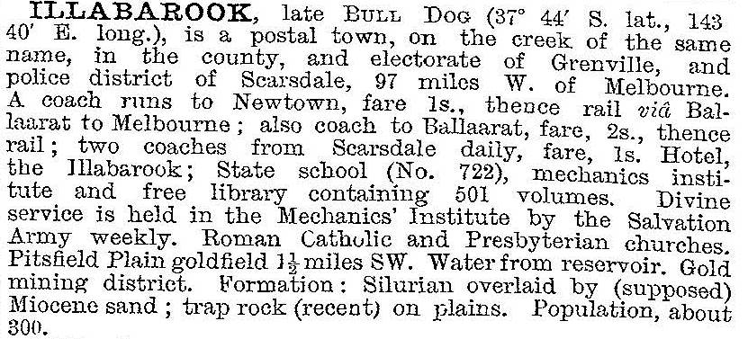
Mining declined during the 1860s but was reactivated in the mid-1890s. A new village evolved and was described in 1903 in the Australian handbook:
The mining was financed by companies to investigate deep leads, and lasted beyond 1910. Thereafter Illabarook relied on agriculture, and the change was reflected in school attendances, reducing to 6 in 1969. During 1911-53 a railway from Newtown to Cressy passed through Illabarook. The Illabarook rail reserve is a woodland biodiversity reserve and is accessed from Cape Clear-Rokewood Road, near the Illabarook memorial hall.
Illabarook has a public hall, a recreation reserve and old gold workings to the west, south and east. Illabarook’s football team, the Bulldogs, is in the Lexton Plains Football League. Its census populations have been:
| census date | population |
|---|---|
| 1871 | 368 |
| 1901 | 268 |
| 1921 | 137 |
| 1933 | 103 |
| 1954 | 64 |
| 1961 | 50 |
Further Reading
Allan Bowler, Pitfield Plains and Berringa goldfields, Messrs Clarke and Company, Melbourne, 1899