
Heywood Shire
Heywood Shire was in the Portland district of western Victoria. Its southern boundary was the coast, from the South Australian border to a short distance beyond Tyrendarra. Its northern boundary was in the vicinity of Digby and Branxholme. The shire adjoined the separate municipality of Portland city.
The shire was proclaimed on 8 December 1863, with the title of Portland. Lacking the actual town of Portland, its Council meetings rotated among several townships until the Heywood mechanics’ institute was used for most occasions from 1890. Shire offices were built at Heywood in 1925. On 1 October 1988, the name was changed to Heywood shire.
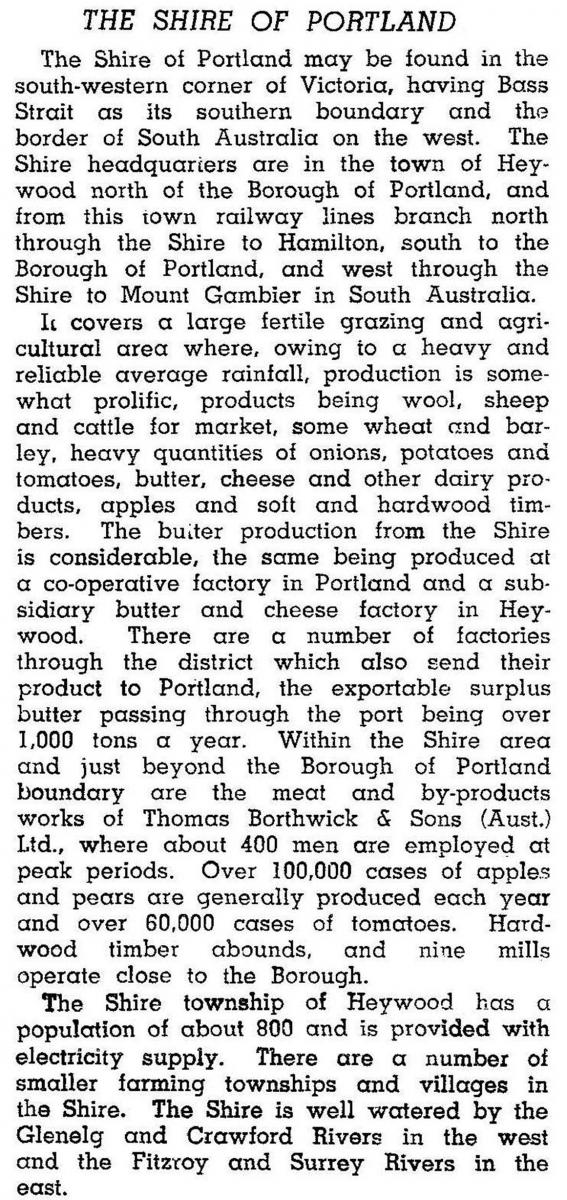
In 1946 when it was still called Portland shire it was described in the Australian blue book:
Apart from the early settlement of Portland there were townships established along the tracks or roads linking Hamilton, Portland, Casterton and Mount Gambier. They included Dartmoor, Digby, Branxholme and Heywood. Much of the land, however, was swampy (for example the Condah district) or heavily timbered. Sawmills were a conspicuous industry and pine plantations have been established around Heywood. Railways came to the shire from Hamilton, via Heywood, to Portland (1877) and from Heywood to Mount Gambier (1916-17). The former is confined to freight and the Mount Gambier line’s service was suspended in 1995.
The shire’s coastal areas were used for dairying and mixed grazing and the northern areas were nearly exclusively sheep and lamb production. Several strong rivers crossed the shire, including the Glenelg, Fitzroy and the Surrey. The Glenelg River touches the Lower Glenelg National Park. Mount Richmond National Park, west of Portland, is formed around an extinct volcano and the Discovery Bay coastal park extends from near Cape Bridgewater to Nelson where the Glenelg River enters Bass Strait.
In 1994 farming occupied 50% of the shire’s area of 3764 sq km. Much of the remaining area was State and plantation forests. There were 582,000 sheep and lambs, 103,000 meat cattle and 12,000 dairy cattle. Small amounts of apples and potatoes were grown.
On 23 September 1994, Heywood shire was united with Glenelg shire and Portland city. The new shire was named Glenelg.
Heywood shire’s census populations were:
| census date | population |
|---|---|
| 1871 | 4261 |
| 1881 | 5945 |
| 1891 | 5116 |
| 1911 | 5291 |
| 1933 | 5433 |
| 1947 | 6194 |
| 1954 | 7056 |
| 1961 | 6982 |
| 1966 | 6550 |
| 1976 | 6183 |
| 1981 | 6614 |
| 1986 | 7211 |
| 1991 | 7125 |
Parts were severed and added to Portland in 1958 and 1968.
Further Reading
Noel F. Learmonth, Four towns and a survey, Hawthorn Press, 1970
W.H. Matthews, They blazed the track: a story of the pioneers of Heywood and district, c1961
Glenelg shire, Bolwarra, Branxholme, Condah, Dartmoor, Digby, Drumborg, Gorae, Heywood, Narrawong, Nelson, Tahara, Tyrendarra and Wallacedale entries