
Gordon Shire
Gordon Shire (1885-1995), in north-west Victoria, had an area of 203 sq km and a population of about 2900 people when it ceased in 1995. It was unrelated to the township of Gordon between Ballan and Ballarat.
The shire’s eastern boundary was the Bendigo/Mount Hope Creek and its western boundary was an irregular line north from Lake Marmal. Its southern boundary was in the vicinity of Mitiamo, and its northern boundary near Barraport. The Loddon River ran north through the middle of the shire.
Gordon shire was created on 29 May 1885, by severance from Swan Hill shire, and was named after General Charles Gordon who was killed at the siege of Khartoum, Sudan, on 26 January 1885.
At the time of the shire’s creation there were northerly railway lines to Boort (1883) and through Pyramid Hill to Kerang (1884). Local waterworks trusts had been formed, the first being the Loddon Trust in 1882. In 1886 the Tragowel Plains Irrigation Trust was formed, encompassing an area of 920 sq km west of Pyramid Hill. It was the first irrigation scheme of national importance in Australia.
The oldest, and probably most populous, village was Durham Ox. It had originated as the Duck Swamp pastoral run (1843) and had a hotel, a court house, a school and a church. It was the administrative centre for the waterworks trust and took the same role for Gordon shire. The Council offices were moved to Boort in about 1909 and Council meetings did not move to there from Durham Ox until around the outbreak of World War II.
Boort and Pyramid Hill, situated on the railway lines and with irrigated farm hinterlands, became the shire’s two main townships. Other villages on the lines also developed. Terrick Terrick, a surveyed town 1 km in extent has disappeared, and Durham Ox has lessened in importance.
Much of the former Gordon shire has irrigation or stock water supplies. The predominantly level plains are interrupted by granite rises, notably Mount Hope, Mount Terrick Terrick and Pyramid Hill in the eastern sector.
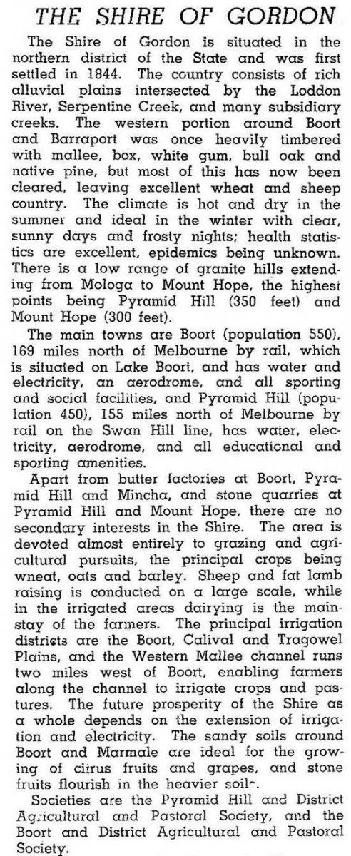
In 1946 the shire was described in the Australia blue book:
In 1994 farm activity occupied 86% of the shire’s area. There were 308,000 sheep and lambs, 17,200 meat cattle, 10,000 pigs and 8000 dairy cattle. Cereals were grown on 31.8% sq km, and production included 38,800 tonnes of wheat and 24,300 tonnes of barley.
On 19 January 1995, most of Gordon shire was united with East Loddon shire, part of Greater Bendigo city and parts of Bet Bet, Maldon and Tullaroop shires to form Loddon shire.
Gordon shire’s census populations were:
| census date | population |
|---|---|
| 1891 | 4033 |
| 1911 | 3294 |
| 1921 | 3150 |
| 1933 | 3504 |
| 1947 | 2705 |
| 1954 | 2969 |
| 1966 | 3320 |
| 1971 | 3124 |
| 1981 | 2990 |
| 1991 | 2750 |
Further Reading
Brendan Monks, A land so inviting: a history of the Shire of Gordon 1885-1985, c1985
Tragowel Plains Irrigation Trust: a brief history 1886-1906, Rural Water Commission, Pyramid Hill, 1986
Barraport, Boort, Mincha, Mologa, Pyramid Hill and Terrick Terrick entries