Flinders Shire
Flinders Shire (1874-1994) was at the western end of the Mornington Peninsula, Port Phillip Bay, extending from Point Nepean to an irregular boundary that began immediately south of Mount Martha and ended at Shoreham on Western Port Bay. It included all the Port Phillip Bay beaches from Portsea to Safety Beach, and the Bass Strait coast including Cape Schanck and Flinders. Its area was 324 sq km.
It began as the Flinders and Kangerong Shire on 24 December 1874. The name came from Captain Matthew Flinders, explorer and navigator, and from land known as the Kangerong basin.
The Kangerong basin was taken as a special survey purchase, eight square miles in area, by Hugh Jamieson in 1841. The survey ran inland from Safety Beach (see separate entry). Its boundaries were: south side, Nepean Highway, Dunns Creek Road and prolongation; east side Bulldog Creek Road and prolongation; north side Foxeys Road and prolongation to coast. The east and north boundaries survived as shire boundaries, and as postcode boundaries to this day. Jamieson built Kangerong house on his survey land, and a County of Mornington map (1858) named the land Kangerong. It is thought that the name derived from an Aboriginal expression describing hailstones.
Flinders was the shire's southerly point of settlement and Kangerong was its northerly point.
The shire's other places of settlement were Point Nepean (quarantine station and fortification protecting the entrance to the bay), Portsea and Sorrento (holiday resorts), Rye (fishing and lime extraction), Cape Schanck (lighthouse) and Dromana. Arthurs Seat, near Dromana, was the most prominent land form, backing on to ranges which were used for timber harvesting, orchards and dairying. The settlements in the ranges included Main Ridge and Red Hill. Timber was also cut from the coastal areas for lime burning and, later, bakers' ovens. Much of the sheoak and banksia were replaced by tea tree regrowth.
Bay steamers popularised Portsea, Sorrento and Dromana, and even greater popularisation came with motor cars and foreshore camping. Rosebud emerged as the urban regional centre, and in the 1970s the shire completed the transfer of its work depot and shire offices from Dromana to Rosebud. Rail transport to the shire was non-existent along Port Phillip Bay (the line terminating at Mornington), but a branch line entered it from the south-east, with stations at Merricks and Red Hill. The line (1921-54) carried mainly goods and orchard produce.
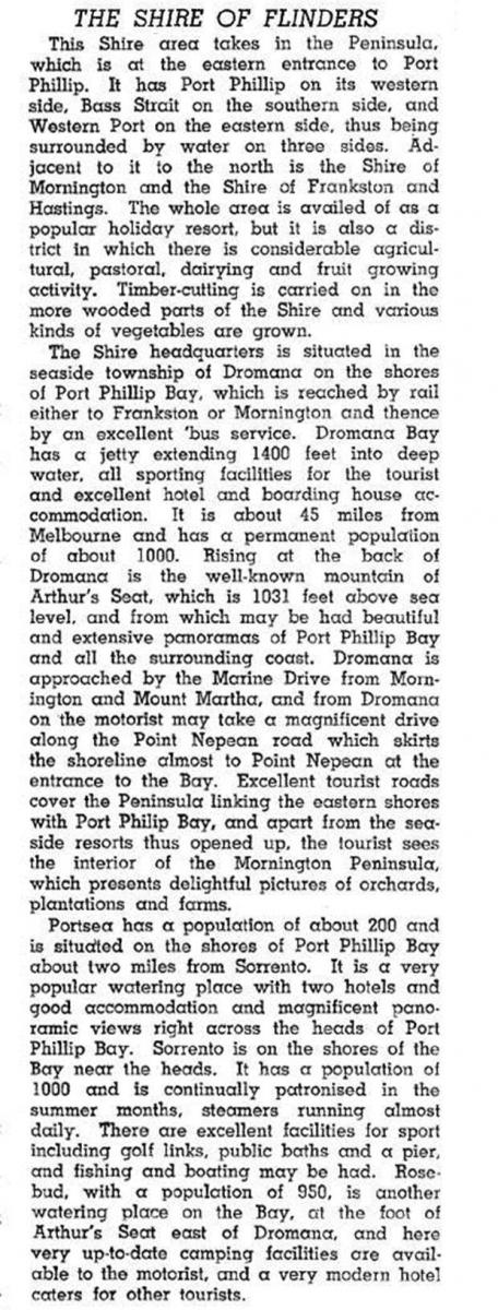
Flinders shire was described in the 1946 Australian blue book:

In 1966 Dromana-Portsea was enumerated as one unit for the population census. It had 79% of the shire's population. Motor traffic drew vastly more holiday makers, and Point Nepean Road was duplicated in stages by the Mornington Peninsula Freeway to ease the traffic congestion.
Flinders Shire had numerous safe beaches on Port Phillip Bay and surf beaches on Bass Strait. The Port Phillip Bay area is continuously urban as far as Point Nepean. Cliff top house sites at Portsea command multi million dollar prices and Sorrento has several surviving grand houses and hotels. Far less opulent housing is found at Rosebud and Rye. The inland hills and ranges have attracted holiday homes and day trippers, with galleries and wineries. There are golf courses at Rosebud, Sorrento and Cape Schanck.
In 1994 farming occupied 35% of the shire's area. There were 9250 meat cattle, 6250 sheep and lambs and an apple crop of 1.97 million kilograms. The numerous small wineries harvested 265 tonnes of grapes.
On 15 December 1994, Flinders Shire was united with Hastings and Mornington Shires and Frankston city to form Mornington Peninsula Shire.
The shire's census populations were:
| census date | population |
|---|---|
| 1881 | 1727 |
| 1891 | 2518 |
| 1911 | 2977 |
| 1921 | 4755 |
| 1933 | 5810 |
| 1947 | 7651 |
| 1954 | 12,072 |
In 1960 part of the shire was transferred to Hastings Shire, and the subsequent populations were:
| census date | population |
|---|---|
| 1961 | 10,512 |
| 1966 | 12,525 |
| 1971 | 15,481 |
| 1976 | 22,100 |
| 1981 | 27,000 |
| 1986 | 33,065 |
| 1991 | 36,516 |
On census night in 1961 unoccupied houses comprised 57% of the shire's 7914 houses. In 1991 unoccupied houses comprised 54% of the total, indicating a slight proportional decline in holiday houses. The total number of houses was 32,262.
Further Reading
Charles N. Hollinshed, Lime land leisure: peninsular history in the Shire of Flinders, Shire of Flinders, 1982
Carlotta Kellaway and Helen Lardner, Shire of Flinders heritage study, 2 vols, Shire of Flinders, 1992
Arthurs Seat, Blairgowrie, Boneo, Dromana, Flinders, McCrae, Main Ridge, Mornington Peninsula, Point Nepean, Portsea, Red Hill, Rosebud, Rosebud West, Rye, Safety Beach, St Andrews Beach, Shoreham, Sorrento and Tootgarook entries


