
Donnybrook and Kalkallo
Donnybrook is a rural area with a small residential community near the Merri Creek, 33 km north of central Melbourne. There have been two places called Donnybrook. The present one is the second, created when the railway line, 3 km east of the Hume Highway, was opened in 1872. It took its named from the first Donnybrook, which was on the Hume Highway, and which is now called Kalkallo.
Both places are in the Parish of Kalkallo, which was the name of an estate of W.J.T. (Big) Clarke, the name thought to be Aboriginal for bug trees or tomahawk.
Before either name was given, the Donnybrook on Sydney Road (the Hume Highway) was known as Rocky Water Holes. It was first settled in 1840 and an inn was built in 1841. A Presbyterian church was opened in 1848, which was the site of the district's second school in 1855. The name was changed to Donnybrook in 1853, probably after the Donnybrook Parish in Dublin. Being positioned on the main Sydney road, Donnybrook acquired hotels (one having stabling for 150 horses), slaughter houses, a flour mill and a tannery.
The area is situated on basalt plains, providing durable building material but experiencing extremes of heat and cold during unpleasant seasonal conditions.
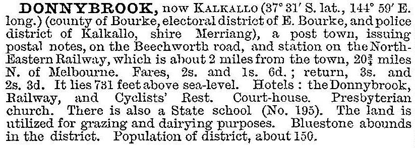
When the railway line was opened in 1872 the nearby station and new village were named Donnybrook and two years later the original Donnybrook was named Kalkallo. Its trade and activity declined as traffic transferred to the railway. The Australian handbook described Donnybrook (Kalkallo) in 1903:
The area was used for dairying until World War II after which ordinary grazing took over. Donnybrook has a cheese factory and a mineral spring with picnic and cabin facilities.
The area's bluestone heritage is visible in St John's Presbyterian church (1861) at Kalkallo and in a bridge (1876) over the Merri Creek between Kalkallo and Donnybrook. Both are on the Register of the National Estate. The historic Donnybrook cemetery is in Kalkallo. It adjoins a significant indigenous grassland. Kalkallo’s position on the Hume Highway has made it better known than Donnybrook. It has a hotel and a service station. In 2011 a 1120 hectare farm was acquired by a developer for a mixed use estate, including a new railway station, near Kalkallo.
Kalkallo joined the group of towns promoting the Old Hume Highway Route 31 as a tourist route in 2014.
In the 1840s the area's population was about 400. Census populations for Kalkallo and Donnybrook have been 136 (1911) and 224 (1954).
Further Reading
J.W. Payne, The Plenty: a centenary history of the Whittlesea Shire, Lowden, 1975