
Costerfield
Costerfield is a former mining locality in undulating to hilly country 10 km north-east of Heathcote and 50 km east of Bendigo.
It was named after two of the four discoveries of gold and antimony in the locality in 1861. The discoverers were Peniston and Alan Coster, Edwin Field and Mr Youle. The mines were allied to the McIvor district gold diggings discussed under McIvor shire. The Costerfield Gold and Antimony Company worked the area for several years, sinking shafts to over 150 metres by 1874.
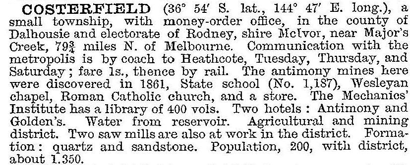
An Anglican school was opened in 1862, and education was conducted there and in a church hall until a government school was opened in 1875. In 1903 the Australian handbook described Costerfield:
There were outlying localities at Costerfield North and South, where hotels were licensed until 1930 and 1913 respectively.
Mining continued on a reduced scale with a revival in the 1920s and 1930s. However, population declined, resulting in closure of the school in 1950. The school re-opened in 1962 and had 11 pupils in 1981, and closed in 1992.
Costerfield has forested country to its north and undulating farm land to the south. The former village is marked by several ruins, but there are a Uniting church and a modern public hall. A Spring-time attraction is the showy ground-cover flowers in the forest areas. The Costerfield Gold and Antimony Mining precinct is a registered heritage area on the Costerfield-Redcastle Road. The community protested against the expansion of the gold and antimony mine by Mandalay Resources in 2014 due to the toxic dust from the site.
Costerfield’s census populations have been:
| census date | population |
|---|---|
| 1871 | 353 |
| 1881 | 542 |
| 1901 | 148 |
| 1921 | 403 |
| 1933 | 176 |
| 1947 | 83 |
| 1961 | 61 |
Further Reading
J.O. Randell, McIvor: a history of the Shire of McIvor and the township of Heathcote, 1985
Anne Bradley, Pioneers of Costerfield, Strathfieldsaye, 2009