
Clyde and Clyde North
Clyde is a rural and residential district 48 km south-east of Melbourne and 6 km east of Cranbourne.
It was named after the Clyde Creek, a watercourse between two early pastoral runs. The stream flowed eastwards to the Koo Wee Rup Swamp about 6 km away. It is thought that the name was inspired by the Clyde River, Scotland.
Clyde North
An early building in Clyde North was the Cranbourne National school (1858). Wesleyan and Anglican churches (1864, 1870), a general store and a public hall (1884) with a library were opened near the school. In 1888 the railway line from Dandenong to Tooradin was opened, passing about 1 km south of the township.
Clyde
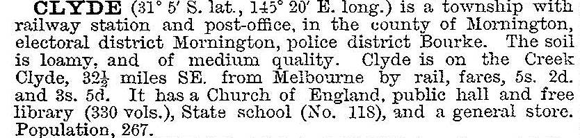
A new Clyde formed around the railway station and the old Clyde became Clyde North. A school at the new Clyde township was opened in 1910, a Methodist church in 1909 and a hall in 1928. Clyde was described in the 1903 Australian handbook:
Modern Clyde District
The railway village acquired a sports oval in 1978 and extensive market gardens to its north. Several amenities, however, have closed: the railway line in 1993, the Methodist/Uniting church in 1999 and the Anglican church in Clyde North also went in 1999 when the building was moved to Pakenham.
Clyde has a mechanics' institute hall, a general store, CFA station and a primary school which had 239 pupils in 2014. Clyde North's school closed in 1992, but there are sites reserved for new State primary and secondary schools not far from the southern boundary of built-up Berwick. Hillcrest Christian college opened in Clyde North in 1982. The proposed Clyde North primary school was among 11 new schools announced by the State Government in 2014.
Clyde's sandy loams are ideal for market gardening and are part of Melbourne's food bowl. They are also in the way of the next big urban surge with land rezoned for houses despite some opposition.
Clyde's census populations have been:
| Area | census date | population |
|---|---|---|
| Clyde | 1901 | 178 |
| 1911 | 328 | |
| 1921 | 388 | |
| 1947 | 267 | |
| 1961 | 325 | |
| 2006 | 1224* | |
| 2011 | 769 |
* Included environs, from Berwick to the South Gippsland Highway, from Cranbourne Road to Cardinia Creek.
At the 2011 census, mushroom and vegetable growing and plant nurseries accounted for 9.3% of employment.
Further Reading
John Campbell, A Clyde history, Clyde 1978
Niel Gunson, The good country, Cranbourne Shire, Melbourne, 1968
The Age, 26 May 2012